| |
|
Ocean Radar (WRC-2012)
|
The International Telecommunication Union (ITU), charged by the United Nations with coordinating global radio spectrum use, came to an agreement in February 2012 that will foster improvements in ocean radar technology, which may eventually allow near real-time detection and tracking of tsunamis and prediction of the likely paths of oil spills, ocean debris and persons lost at sea.
Global interest in ocean radars increased dramatically in recent years due to events such as the Gulf oil spill and the massive loss of life caused by the Indonesian and Japanese tsunamis. February's action by the ITU's 2012 World Radiocommunication Conference (WRC) provided specific radio frequency bands for ocean radars, which until now operated only on an informal basis and were subject to immediate shut-down if they caused interference with other radio systems.
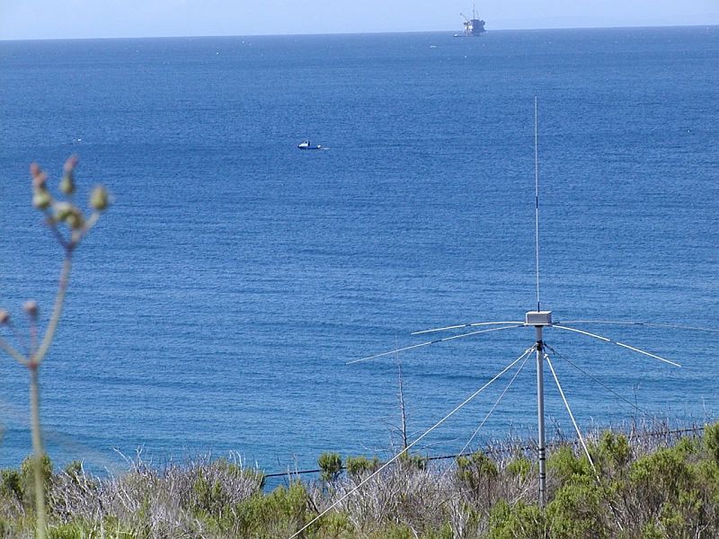
Ocean radars are small radio systems typically installed on beaches and use radio signals to map ocean currents to distances as great as 100 miles. Users typically employ them for science, including the study of global ocean currents and their role in weather and climate change.
With further technical developments, including a reduction in the time between taking radar measurements and constructing maps of ocean currents, ocean radars could be used to alert authorities to the existence of tsunamis resulting from earthquakes and follow their path in near real time, allowing better warnings of impending dangers. The radars may also be able to predict the likely path of persons or vessels lost at sea and to predict the evolution of debris fields and oil spills after shipwrecks or oil rig disasters.
"The WRC's decision to identify dedicated ocean radar bands will help speed up technological development of these radars," said Andrew Clegg, a radio spectrum manager with the U.S. National Science Foundation (NSF), who chaired the international drafting group at the WRC that developed the ocean radar spectrum solution. "Many countries, particularly those recently devastated by ocean disasters, were particularly interested in reaching a global agreement for the use of ocean radars."
|
Frequency Bands |
| Band | Use | Service11 | Table |
| 4438 - 4488 kHz | Ocean radars (primary in Region 2; secondary in Regions 1 & 3) | Radiolocation | - |
| 5250 - 5275 kHz | Ocean radars (primary in Region 2; secondary in Regions 1 & 3) | Radiolocation | - |
| 9305 - 9355 kHz | Ocean radars (secondary in Regions 1 & 3; no allocation in Region 2) | Radiolocation | - |
| 13450 - 13550 kHz | Ocean radars (secondary in all ITU Regions) | Radiolocation | - |
| 16100 - 16200 kHz | Ocean radars (primary in Region 2; secondary in Regions 1 & 3) | Radiolocation | - |
| 24450 - 24650 kHz | Ocean radars (secondary in Regions 1 & 3; 24450-24600 primary in Region 2) | Radiolocation | - |
| 26200 - 26420 kHz | Ocean radars (primary in Region 2; 26200-26350 secondary in Regions 2 & 3) | Radiolocation | - |
| 39 - 39.5 MHz | Ocean radars (secondary in Region 1) | Radiolocation | - |
| 39.5 - 40 MHz | Ocean radars (primary in Region 3) | Radiolocation | - |
| 41.015 - 41.665 MHz | Ocean radars (primary in U.S. and Rep. of Korea) | Radiolocation | - |
| 43.35 - 44 MHz | Ocean radars (primary in U.S. and Rep. of Korea) | Radiolocation | - |
Associated Files:

An ocean radar at Refugio State Beach, California. The Interdisciplinary Oceanography Group at the University of California Santa Barbara operates the radar, which is sponsored in part by the National Science Foundation.
|
|
|
|
|